Santa Monica Gets Down to Downtown Specifics

By Jorge Casuso
April 29, 2013 -- What should be the maximum height of buildings in Downtown Santa Monica? What changes need to be made to spur walking and bicycling? And how do you encourage motorists to ditch their cars or park them away from the Downtown center?The answers to these key questions are becoming more pressing as City officials forge a new Downtown Specific Plan that sets standards tailored to the needs of the area and is based on input from stakeholders and members of the community.
The next community meeting -- set for Tuesday, May 6, at 7 p.m. in the East Wing of the Civic Center -- will seek input on the density and heights allowed for projects Downtown. And with a slew of major developments proposed for the area, next week’s meeting already has mobilized slow-growth advocates, who believe City officials are ignoring their concerns.
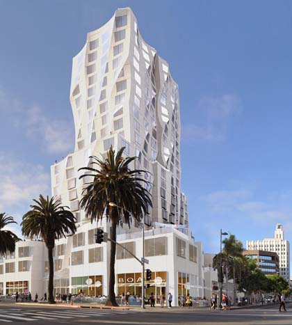 |
| The tower viewed from the west side of Ocean Avenue (read article) |
“Judging from the amount of proposed downtown development we are seeing, our City will look vastly different in a few years,” read an email sent by the Santa Monica Coalition for a Livable City (SMCLC) earlier this month. “As residents it's up to us to tell our City planners, the Planning Commission and the City Council how much growth we want for our city center.”
The Specific Plan taking shape incorporates guidelines set by the City's Land Use and Circulation Element (LUCE), which was approved in 2010 and sets the blueprint for development in Santa Monica for the next two decades.
The LUCE, however, defers to the Specific Plan for setting height regulations, and City staff has identified seven “opportunity sites” for projects that could exceed height and density limits if they are near transit, can accommodate mixed–use development and would be safe and inviting for pedestrians.
After three community meetings last year, a preliminary discussion by the City Council and four hearings by the Planning Commission, the debate is centered on the proposed “opportunity sites” that will leave height and density to the final discretion of council.
Major projects already being proposed at three of the opportunity sites are the 556,000-square-foot Miramar redevelopment project along Ocean Avenue north of Wilshire Boulevard; the proposed 333,376-square-foot tower designed by architect Frank Gehry at the corner of Santa Monica Boulevard and Ocean Avenue, and the redevelopment of the Holiday Inn on Colorado Avenue and 2nd Street, which has not yet been officially submitted.
Other proposed sites are the City-owned 127,000-square-foot parcel at 4th and 5th streets and Arizona Avenue, the Sears building at 4th Street and Colorado Avenue, the Fred Segal building at Broadway and 4th Street and the Expo Line Station at the former location of the Sears Automotive building.
In order to exceed the zoning standards, developers would need to provide at least three of the following community contributions: affordable housing, significant open space, exceptional architecture, cultural funding, significant contributions to environmental sustainability, expanded access in and around the Downtown and more than 100 public parking spaces.
City officials also believe it is important that the new Downtown Specific Plan continue to allow smaller buildings in the district to remain at the same general height as the 1986 plan. Such incentives spurred the creation of new, vibrant neighborhood areas Downtown.
On January 23, the Planning Commission discussed staff’s proposal to retain the current height limits for projects outside the “opportunity sites.” Heights for “tier one” (the smallest projects) would be set at 48 feet, while the “tier three” (the largest) could go as high as 84 feet.
In addition to setting height and density limits, the plan also will set goals and standards for traffic and circulation in an area that boasts the highest concentration of employees and pedestrians in the beachside city and is its main tourist and shopping destination.
“We want to find a way to really extend the vibrant street life to Downtown’s boundaries,” said Francie Stefan, the City’s strategic and transportation planning manager. “It has to be a balanced strategy.
“There has to be the opportunity to walk and bike, but there also has to be the opportunity to drive or take public transit,” Stefan said. “We’re all diverse users of our transportation system. There’s no one answer for everyone.”
On March 6, City staff presented the Planning Commission with ideas and possible tools for the circulation component of the proposed Downtown Specific Plan. The plan's key goals — decrease vehicle traffic and make it safer and more inviting to walk and bike Downtown.
In addition to furthering the “park-once” strategy that encourages motorists to walk after arriving Downtown, a number of ideas were generally accepted by the commission.
They included creating wider sidewalks through private property setbacks (especially along Lincoln), synchronizing lights to make traffic flow more smoothly, and insuring that the public transit system provides good access to Downtown.
Other proposed strategies include expanding roadways and adding parking at two sites near the I-10 Freeway and another near the Downtown station for the long-anticipated Expo Light Rail line. As many as 400 passengers are expected to get on and off the trains every five minutes during peak hours.
Planning staff expects to present the Downtown Specific Plan to the council in July. An Environmental Impact Report (EIR) would then be issued. The plan and EIR would be submitted to the council for a final review and adoption “after the first of the year,” said David Martin, the City’s planning director.